Tow and Behold!
- Ocean Hoptimism

- Sep 7, 2025
- 4 min read
Updated: Sep 27, 2025
The Story of Manta Tow Reef Surveys
When you read headlines about the state of coral reefs. declining cover, bleaching outbreaks, resurgent recovery, there’s usually an unglamorous backstory about how those numbers were collected. Reef monitoring isn’t just white coats and lab benches. It’s saltwater, sunburn, and a technique that looks more like a rodeo stunt than sober science. Enter: the manta tow.

Origins in Crisis
The manta tow was born in the 1960s during a moment of panic. Crown-of-thorns starfish (Acanthaster planci), voracious predators of coral, were erupting across parts of the Great Barrier Reef, stripping reefs bare. Scientists needed a way to cover huge stretches of reef quickly to understand the scale of the outbreak. The solution was almost absurdly simple: put a snorkeler on a board, drag them slowly behind a boat, and have them count what they see. What began as a crisis tool soon became one of the most widely used methods for large-scale reef surveys.
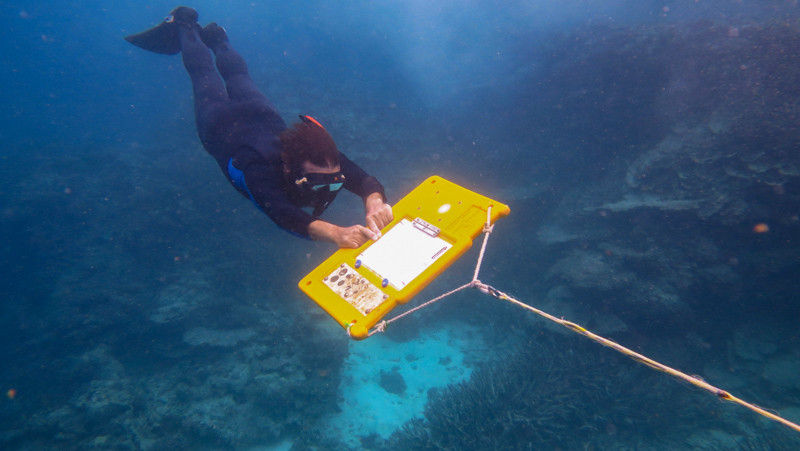
The Mechanics of a Tow
Picture it: a researcher, fins fluttering, grips a fiberglass board shaped like the wings of a manta ray. A rope links them to the boat, which idles forward at just the right speed: fast enough to cover ground, slow enough to keep human lungs and eyes useful. The snorkeler’s job is laser-focused: scan the reef as it rushes beneath, recording on a waterproof slate the estimated coral cover, fish abundance, bleaching patches, starfish, debris, even the odd passing shark. Each tow lasts about two minutes, after which the boat idles, the data are called out and logged, and the snorkeler catches their breath before diving back in.
It’s science stripped to its essentials: eyes, water, and a good pair of lungs.

Why Manta Tow Works
For reef systems that span hundreds or thousands of square kilometers, manta tow offers something no other method can match: speed. SCUBA transects deliver detail but are slow, costly, and limited to small plots. Satellite imagery gives scale but can’t yet see the fine distinctions of live coral versus rubble or turf algae. Manta tow bridges the gap:
Scale – Cover vast reef tracts in a single day.
Simplicity – Minimal gear, no tanks, no decompression limits.
Flexibility – Works at low tide, high tide, or in remote corners where logistics are brutal.
Continuity – Decades of manta tow data create a rare long-term picture of reef health.
The Human Element
But make no mistake: manta tow is no tropical daydream. Manta tow is grueling. Imagine hours spent being tugged through surge and chop, salt stinging your eyes, data slate smudged, visibility shifting with clouds and currents. Observers must make split-second calls: Was that rubble or live coral? Was that three crown-of-thorns or five? Accuracy rests on skill, training, and stamina.

And then there are the reefs’ less-predictable residents. Sharks often patrol the same zones surveyed. Most encounters are benign, a curious blacktip circling once before vanishing, but observers must know the difference between casual inspection and territorial display. It adds an edge of adrenaline to the day’s data sheet.

Limits and Caveats
Manta tow isn’t perfect. It’s subjective, shaped by the skill of the observer and the fickleness of visibility. It’s limited to shallow reef flats and crests. Anything deeper than 10–12 meters lies beyond reach. It can’t capture fine-scale changes like juvenile coral recruitment or subtle shifts in species composition. But when the goal is to spot broad trends, outbreaks, or mass bleaching, it remains unmatched.
What the Data Deliver
From Lady Musgrave Island in the south to Lizard Island in the north, manta tow surveys across the Great Barrier Reef have generated a treasure trove of knowledge. The same is true for remote atolls in the Pacific and Indian Oceans. They reveal coral cover trends, the geographic march of bleaching events, the waxing and waning of crown-of-thorns populations, and the spread of ghost nets and marine debris. Governments, NGOs, and scientists rely on these data to make urgent decisions: where to send divers for eradication programs, which reefs need stricter protections, how to prioritize conservation investments.
A Human Chain of Knowledge
Every statistic you hear about reef decline or recovery is built on the effort of people gripping boards, salt-stung and sunburned, who transformed fleeting glimpses into hard data. Behind every headline number, “Coral cover down 50%,” “Bleaching widespread,” there’s a chain of people who turned water into knowledge. Manta tow is both humble and heroic: an improvised solution that grew into a gold-standard tool. And it’s a reminder that science is not just numbers on a page; it’s people in the water, eyes wide open, pulled through tide and chop to bring us the truth of the reefs.
Next time you hear that reefs are declining (or, more hopefully, recovering), remember the snorkeler being hauled along reef edges, eyes scanning tirelessly, turning fleeting underwater glimpses into data that shape global conservation. It’s science. But it’s also grit, salt, and a stubborn love for coral reefs.
© 2025 Ocean Hoptimism. Reuse with credit only.


Comments